
Spain will go in a few hours from extreme heat to a much cooler and more unstable scenario. The State Meteorological Agency anticipates a "significant change in weather" starting this Thursday, August 20, with a generalized drop in temperatures and the arrival of rain, storms, and hail to numerous areas of the Peninsula and the Balearic Islands.
The drop will reach up to 10 or 12 degrees in some cities between this Wednesday and Friday. Valencia will go from maximums close to 42 degrees to about 30, while Zaragoza will drop from 42 to 31 and Logroño from 39 to 28. Burgos and Soria will stay around 25 degrees after being around 35, and León will fall from 33 to values close to 24.
⚠️ NOTA INFORMATIVA | Lluvias generalizadas en el norte y este peninsulares.
— AEMET (@AEMET_Esp) August 19, 2026
➡️ Podrá haber inundaciones locales, sobre todo en el entorno de los Pirineos.
➡️ El jueves, tormentas con granizo grande y viento muy intenso en zonas del sureste.
+ info 👉https://t.co/0qneNvQx4A pic.twitter.com/ZYufpm0Jcu
The shift will be caused by a trough that will quickly cross the Peninsula accompanied by a cooler polar air mass. A trough is an elongated band of low pressure and cold air in the upper layers of the atmosphere. Its arrival over a still very hot surface favors the formation of large developing clouds, storms, and intense wind gusts.
The change will continue over the weekend with a second, broader trough located to the west of the Peninsula and a slow-moving front. The combination of cold Atlantic air with Mediterranean humidity will increase instability especially in the north and northeast, where precipitation may be persistent and accumulate significant amounts.
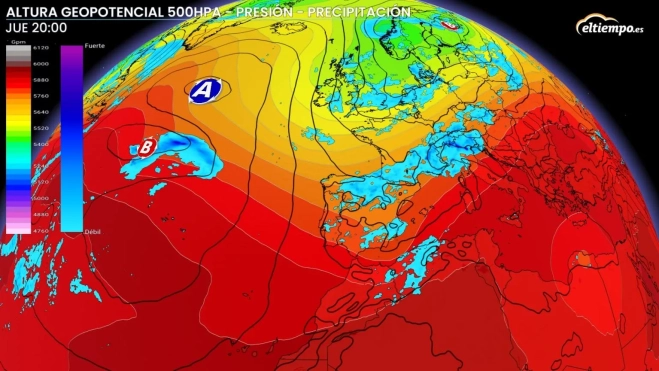
Where and when the change will be most pronounced
On Thursday 20, a front will arrive in Galicia, extending rains towards Asturias, Cantabria, and the Basque Country. During the afternoon, stormy showers will appear in much of the northern half and the eastern third, with a special impact on Castilla y León, La Rioja, Navarra, Aragón, Catalonia, and areas of the Valencian Community.
The most delicate situation could occur in the southeastern peninsula. AEMET warns of very strong storms, downbursts, violent gusts, and hail that can reach a considerable size in parts of Murcia, the south of the Valencian Community, Albacete, and the eastern areas of Andalusia. The instability will advance towards the Balearic Islands during the last hours of the day.
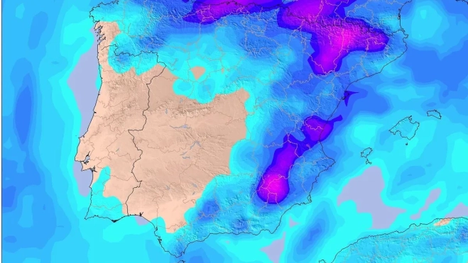
The thermal drop on Thursday will be pronounced in almost the entire Peninsula and could be notable in the northern third and the southeast. The change will be especially clear in the interior of Galicia, Asturias, the north of Castilla y León, La Rioja, Navarra, Aragon, and the Ebro valley. Maximum temperatures will also drop in Madrid, Castilla-La Mancha, Extremadura, and inland Andalusia, although rainfall there will be more irregular.
During Friday 21, precipitation will continue in the Cantabrian Sea, the northeast, and the Balearic Islands. It will lose intensity throughout the day in the Cantabrian communities, while in Catalonia, Aragon, the Valencian Community, and the Balearic archipelago, locally strong showers may still appear.
Relief will also arrive during the nights. León could go from a minimum of 18 degrees to about 11, Burgos will drop from 17 to 12, and Madrid will leave tropical dawns to settle around 19 degrees. In a large part of the Peninsula, temperatures will be somewhat below the usual values for the second half of August.
On Saturday 22 and Sunday 23, rains will intensify again in Galicia and the Cantabrian communities. Instability will also increase in Navarra, La Rioja, Aragon, Catalonia, and the north of the Valencian Community. The central and eastern Pyrenees will concentrate the greatest risk of strong and persistent precipitation, with possible local floods in valleys and ravines.
Some models contemplate accumulations exceeding 100 liters per square meter until Sunday in parts of the central and eastern Cantabrian Sea, northern Navarra, and Aragon. AEMET maintains high caution regarding these amounts because the exact location and intensity of the maximum accumulated values still present much uncertainty.
Storms could reach areas of Castilla y León, Madrid, Castilla-La Mancha, Extremadura, and western Andalusia over the weekend, though more scattered. The southern and western peninsular regions will share the temperature drop but will remain further away from the persistent rainfall expected in the Cantabrian Sea and the northeast.
The Balearic Islands will first experience a hot day, with maximums that could approach 37 degrees in Palma on Thursday, before receiving storms and moderating towards Friday. The Canary Islands will remain outside the most abrupt change, with temperatures close to 26 or 27 degrees in Las Palmas de Gran Canaria and around 31 in Santa Cruz de Tenerife, in addition to some clouds and possible weak rains in the north of the mountainous islands.
The episode could extend until Monday the 24th in the far north of the peninsula. AEMET will update the forecast this Thursday due to the possibility of changes in the areas affected by the heaviest rains, hail, and highest accumulations.
