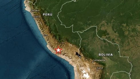
A strong earthquake has shaken this Thursday the Andean region of Ayacucho, in southern Peru, and has been felt in several parts of the country, including Lima. The Geophysical Institute of Peru has set its magnitude at 7.2, although initial estimates from other international organizations offer lower figures. So far, Peruvian authorities have not confirmed victims.
The movement occurred at 1:00 p.m. in Peru, 8:00 p.m. in peninsular Spain, with an epicenter 35 kilometers north of Coracora, capital of the Ayacucho province of Parinacochas. The report from the National Seismological Center places the focus at 108 kilometers deep and indicates an intensity of grade III-IV in Coracora.
SEISMIC REPORT:
— National Seismological Center (@Sismos_Peru_IGP) August 20, 2026
IGP/CENSIS/RS 2026-0568
Date and Local Time: 20/08/2026,13:00:16
Magnitude: 7.2
Depth: 108 km
Latitude: -14.70
Longitude: -73.78
Intensity: III-IV Coracora
Reference: 35 km N of Coracora, Parinacochas - Ayacuchohttps://t.co/TpjDs4Ge1R
Measurements still show significant differences. The United States Geological Survey has lowered the magnitude to 6.7 and calculated a depth of 66.7 kilometers. Its epicenter appears 38 kilometers northwest of Upahuacho, within the same province of Parinacochas. These divergences are common during the first hours and can be corrected when seismic centers review all available records.
The earthquake has been felt in several regions of southern Peru. Data collected by the USGS confirm that the tremor reached Ica and Arequipa, while the IGP has reported a slight perception in Lima, located approximately 650 kilometers from Coracora.
Coracora and Ayacucho review possible damages
The head of the Geophysical Institute of Peru, Hernando Tavera, explained that "for now nothing critical has happened", although he asked to wait for the review of the towns located around the epicenter to be completed. The Regional Emergency Operations Center keeps checks open together with provincial and municipal authorities.
The mayor of Coracora told Peruvian public television that the movement was clearly felt in the central area of the city. The initial municipal survey has not detected serious damage, although inspections continue in homes, roads, schools, health centers, and rural communities of Parinacochas.
Local media and journalists have disseminated images of rockfalls and possible damage to some homes in Ayacucho. These damages still lack a consolidated assessment from COEN or the National Institute of Civil Defense, so their extent remains pending verification. No injured, deceased, or missing persons have been officially reported either.
#ALERTA nos envían imágenes y reportes del movimiento telúrico en Ayacucho #Ayacucho #ULTIMO pic.twitter.com/KjBTDF6upw
— Pablo Ramos Rivas (@pabloramosrivas) August 20, 2026
The depth of the earthquake has allowed the energy to be perceived over a very wide territory and, at the same time, has initially reduced the violence of the shaking on the surface. A high magnitude does not automatically imply the same intensity in every locality. Magnitude measures the energy released, while intensity records the observed effects at a specific point.
The epicenter is located in the interior of the country and far from the coast. The earthquake has not activated any tsunami alert on the Peruvian coasts, as the continental origin of the movement prevents a direct displacement of the seabed like the one that can cause large waves.
An almost identical precedent next to Coracora
The area is well acquainted with this type of movement. On August 24, 2014, the IGP registered another earthquake with an epicenter 35 kilometers north of Coracora, exactly the same reference reported this Thursday. That earthquake reached a magnitude of 6.6 and also had its focus at a depth of 108 kilometers.
The toll of that emergency grew as brigades managed to access rural communities. According to data collected then by Indeci, eight people were injured, 149 were affected, and another 705 suffered some type of impact. Also, 141 homes were damaged, 29 were uninhabitable, and two completely collapsed.
Peru is located in the so-called 'Pacific Ring of Fire', one of the areas with the highest seismic activity on the planet. The Nazca plate subducts beneath the South American plate, a continuous movement that accumulates and releases energy through earthquakes at different depths.
The country suffered a new seismic emergency in July in the central region of Junín. The movements recorded around the Mantaro valley left fatalities, dozens injured, and numerous homes destroyed, many of them built with adobe and especially vulnerable materials.
The last major devastating earthquake in recent Peruvian history occurred in August 2007. The 7.9 magnitude earthquake that struck Ica and Pisco caused nearly 600 deaths, left hundreds injured, and destroyed extensive urban areas in the south of the country.
Municipal and regional teams continue to survey Parinacochas and the towns near the epicenter. The official toll will remain open until inspections are completed in rural communities, mountain roads, and the most vulnerable homes in Ayacucho.

This breaking news is being updated. The editorial team of ElConstitucional.es is working to expand the news and offer you the best information.
