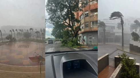
A chain of extremely violent storms has hit the province of Valencia this Thursday with hail, intense rains and several wet downbursts that have generated wind gusts close to 150 kilometers per hour. In just a few minutes, roofs have flown off, trees and palm trees have fallen, and damage has occurred to buildings, roads, and railway lines.
The highest record released by the Associació Valenciana de Meteorologia was located in Sumacàrcer, with 149 kilometers per hour. Alzira reached 143, Corbera 125, and l'Alcúdia 114. More than 100 kilometers per hour were also exceeded in Benimuslem, Carcaixent, Gavarda, Castelló, Sueca, and Cotes.
La tronada que afecta la Ribera està fent molt de mal. Les ratxes de vent estan sent impressionants. De moment:
— AVAMET (@avamet) August 20, 2026
149 km/h Sumacàrcer (Alt de la Ceja)
143 Alzira
125 Corbera
114 l'Alcúdia
106 Benimuslem
105 Carcaixent
105 Gavarda
103 Castelló
103 Sueca
101 Cotes
95 Massalavés pic.twitter.com/1JrTMNf5vb
Alzira is among the most affected towns. The force of the wind has caused serious damage to the Santa Catalina church, where part of the roof and one of the sides has given way, revealing the interior dome. The streets have been strewn with branches, rubble, and other elements detached from the facades.
Ens comenten que hi ha danys a l'Església de Santa Caterina d'Alzira a causa de la forta tronada. Les ratxes a la capital de la Ribera Alta han superat els 140 km/h.
— AVAMET (@avamet) August 20, 2026
Vídeo de Yeimy SosAvi via el grup Alzira Informa. pic.twitter.com/EMNrI0Nu0s
The storm also hit Carcaixent, Algemesí, Riola, Massalavés, and Benimuslem. The Provincial Fire Consortium has had to attend to numerous incidents due to fallen trees, damaged roofs, and obstacles on public roads. The mayor of Carcaixent, Carol Almiñana, has asked residents to remain in their homes due to the risk of further detachments.
⛈️ Precipitaciones muy intensas, en ocasiones acompañadas de granizo, con muy fuertes rachas de viento afectando a municipios como Alzira, Riola y Algemesí
— VOST Comunitat Valenciana (@VOSTcvalenciana) August 20, 2026
📸 13:45h #Meteo #FMA @AEMET_CValencia mantiene activados sus avisos naranjas en esas zonas por lluvias y tormentas 🟠 pic.twitter.com/M8e3YfPwKy
In Cullera and El Perellonet, gusts have torn elements from balconies, knocked down palm trees onto parked vehicles, and sent tables, chairs, and umbrellas flying. A man had to receive assistance after an umbrella hit him on the head on Racó beach, as reported by 'Levante-EMV'.
The storm has also affected the railway network. The fall of a tree onto the infrastructure between Alzira and La Pobla Llarga has caused delays on the C2 commuter line and on medium and long-distance trains, while Adif teams work to remove the obstacle and restore normal circulation.
In Tavernes de la Valldigna, a lightning strike caused a fire in a mountain area. Two aerial units, two forest fire brigades, and a helitransported brigade have participated in the extinction efforts, initially complicated by strong winds.
The line of instability has advanced from the Region of Murcia and Albacete towards the Valencian Community. In Jumilla, the rainfall has turned several streets into real rivers in a matter of minutes, a sample of the speed with which storm cells are forming and moving.
¡#Tormentas en el interior del sureste de la #PenínsulaIbérica! Esta tarde (20/08/2026), así descarga en #Jumilla (#Murcia), convirtiendo las calles en ríos en pocos minutos. Vídeo: @JuanjoPerez_16. pic.twitter.com/9SwEf9V8lR
— MeteOrihuela (@MeteOrihuela) August 20, 2026
What is a wet microburst and why does it cause so much damage
A wet microburst occurs when an air current descends at high speed from inside a storm and, upon hitting the ground, expands horizontally with extremely violent gusts. Unlike a tornado, the wind disperses from the point of impact and can affect a relatively wide area in a few minutes.
The phenomenon is accompanied by rain and a sudden drop in temperature. In Polinyà de Xúquer, 21.4 liters per square meter were collected, 14.1 of them in ten minutes, while the thermometer dropped from 37.7 to 18.1 degrees. The temperature fell almost 20 degrees during the passage of the storm.
The heat accumulated during the last few days and the entry of very warm and humid air from the Mediterranean have fueled storms that are developing with enormous rapidity. Aemet has asked for special caution near trees, roofs, terraces, and fragile or poorly anchored structures.
20/08 11:54 AVISOS HOY Y MAÑANA | Comunitat Valenciana: lluvias, tormentas, temperaturas máximas y costeros. Nivel máximo de aviso: naranja.
— AEMET Comunitat Valenciana (@AEMET_CValencia) August 20, 2026
Actualizaciones en https://t.co/R3Fs2JzKgr pic.twitter.com/4OKKpBpnHS
The strongest storms will advance during the night towards the Balearic Islands. Aemet maintains the risk of very intense rainfall, hail, and very strong or even hurricane-force gusts during the early morning in Mallorca and Menorca.
