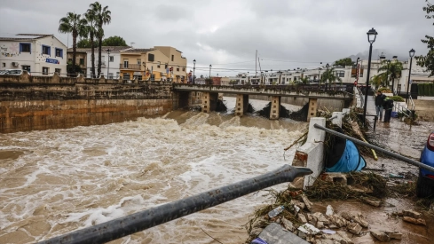
The DANA Adam will keep several points of the territory on alert this Tuesday due to intense rains and storms discharged on the Mediterranean coast, according to the forecast of the State Meteorological Agency (AEMET). The state agency has activated warnings for rain and storms in Mallorca, Ibiza and Formentera, as well as in Barcelona and Girona.
In addition, yellow warnings for rain will remain in Jaén, La Palma and El Hierro, while Barcelona and Girona will also have storm warnings, and Girona will add coastal phenomena.
Instability in the eastern peninsula and the Balearic Islands
The AEMET anticipates that tomorrow a situation of instability will persist in the eastern peninsula and in the Balearic Islands, with cloudy or overcast skies and showers with thunderstorms, which are expected to be strong in the islands and in Catalonia, where they are likely to be locally very strong and leave significant accumulations.
It is also likely that in the early hours locally very strong rainfall will be recorded in areas of the southeast coast. In the rest of the Peninsula, more stable weather will prevail, with partly cloudy skies or with cloudy intervals in the west and the Cantabrian Sea, and otherwise cloudy, although isolated precipitation is not ruled out in areas of Andalusia, the peninsular center and the Cantabrian Sea, with the possibility of being locally strong in parts of Jaén.
Rains will tend to subside during the day
Throughout the day, precipitation will tend to cease from south to north and skies will become partly cloudy, except in the northwest, where the approach of a front will cover the sky. In parallel, it will also snow in high areas of the Pyrenees.
Canary Islands, fog and temperature evolution
In the western islands of the Canary Islands, cloudy skies are expected with showers that could be strong and persistent in El Hierro, without ruling out that they may also be in La Palma. In the rest of the archipelago, cloudy skies will prevail. In addition, morning fog banks will be recorded in mountain areas and on both plateaus.
Regarding temperatures, the AEMET indicates that maximums will decrease in the Balearic Islands, Galicia and the peninsular southwest, will vary little in the Canary Islands and will rise in the rest, with notable increases in regions of the eastern peninsular facade and the northeast interior. Minimums will drop slightly to moderately in the Peninsula and Balearic Islands, with few changes in the Canary Islands, and weak frosts are expected in mountains of the far north.
Westerly wind in the Peninsula
Regarding the wind, the forecast indicates that this Tuesday the westerly component will prevail in the Peninsula. In general, it will blow lightly at the beginning of the day, although it will tend to strengthen, especially on the coasts and in the interior of the eastern peninsula. It will reach strong intervals on the southeast and northwest coasts, and the tramontana, also strong, will be established in the Ampurdán.
In the Balearic Islands, a moderate south wind will blow, turning to west, while in the Canary Islands it will be an easterly component, light to moderate.