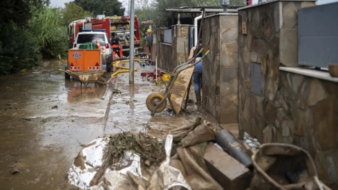
The episode of torrential rains that has affected Spain this weekend has left exceptional records in several parts of Catalonia, where the State Meteorological Agency (Aemet) has confirmed accumulations of more than 200 liters per square meter in towns such as Vilasar de Dalt, in the province of Barcelona, with 226 liters per square meter, and the Drassanes station, in the city of Barcelona itself, with 202 liters.
The spokesperson for Aemet, Rubén del Campo, has detailed that in Vilasar de Dalt, 176 liters per square meter accumulated in just six hours, between Saturday night and early Sunday morning, while on Sunday a torrential downpour was also recorded in Barca Rota, in the province of Badajoz, with 70 liters per square meter in a single hour.
The Mediterranean, a determining factor
Del Campo stressed that one of the most relevant elements of this episode has been the temperature of the Mediterranean Sea, which at the end of September exceeded 26 degrees in the Balearic Sea, a figure, he said, "more typical of late August and a record for the dates on which they were recorded." According to the Aemet spokesperson, such warm waters provide "an extraordinary energy input" that favors the formation of very intense storms and increases air humidity.
In this regard, Rubén del Campo pointed out that it is "an issue that will have to be investigated in greater depth," although he warned that this episode highlights "how the warming of sea waters, driven by anthropogenic climate change, can, in fact does, make situations of torrential rains more adverse."
A DANA will maintain instability
The Peninsula will remain this Monday under the influence of a DANA formed on Sunday west of Portugal, which will favor the appearance of showers in wide areas, locally strong and with hail in inland and eastern areas of Catalonia, while they will be less likely in the southern third of the peninsula. Temperatures will rise and may exceed 32 degrees in the Guadalquivir valley. In the Canary Islands, some showers are not ruled out in the most mountainous islands, where there will also be haze.
On Tuesday, instability will increase and showers with thunderstorms will be more widespread, with the possibility of them falling “almost anywhere,” although with greater intensity in the northern third and the peninsular center, as explained by Rubén del Campo. They could be strong and even very strong, with significant accumulations in Extremadura, western Castilla-La Mancha, and the surroundings of the Sistema Central, in addition to being accompanied by hail. In the Canary Islands, showers may occur throughout the archipelago, while temperatures will be lower throughout Spain except in the Mediterranean.
On Wednesday, the thermal descent will continue, more pronounced in the peninsular north and in the Canary Islands, with abundant rainfall in the northern third, where it will be strong or very strong and persistent in the Cantabrian, the northeast, and the Balearic Islands. From Thursday, more anticyclonic and stable weather is likely to prevail, although intense rains may still be recorded in the far north, Catalonia, and the Balearic Islands. Looking ahead to the weekend, precipitation will decrease from Friday, with cool temperatures for the season and an upward trend in the last days of the week.