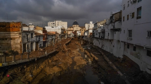
The Government is preparing a tightening of urban planning rules to prevent the continued growth in the number of homes, garages, and essential services built in areas most exposed to floods. The draft royal decree, which will be released for public information this Thursday, will prohibit new residential uses in areas of highest danger and will require informing about flood risk when a home is sold.
The reform comes after extreme weather events that have hit different parts of Spain in recent years and the devastation caused by the DANA in October 2024, which left more than 230 fatalities and entire neighborhoods covered in water and mud in the province of Valencia.
The Ministry for Ecological Transition admits that the regulations in force since 2015 have proven insufficient to contain the occupation of exposed land. Urban developments, exceptions, and projects initiated before the restrictions have allowed the built area to continue increasing even in areas where water flows with greater force during a flood.
The third vice-president and Minister for Ecological Transition, Sara Aagesen, defended this Wednesday in Valencia that the objective is to leave space for rivers and reduce the population's exposure. "There are some areas where construction continues despite being flood-prone areas," she warned during a visit to the headquarters of the State Meteorological Agency.
New homes prohibited in the most dangerous areas
The decree will differentiate between so-called preferential flow zones and the rest of flood-prone areas. The former are those through which the largest amount of water flows during a flood and where the water during a flood and the speed or depth of the current can cause particularly severe damage.
In rural lands located within these zones, their transformation into developable land will be prohibited. Only actions aimed at reducing risk, restoring the river space, or building protection infrastructures against floods may be authorized.
When the land is already urbanized, new residential uses cannot be approved. Also, underground garages, basements, and any dependency built below ground level will be expressly prohibited, spaces that can become traps during a sudden flood.
The limitation responds to one of the main lessons left by recent floods. Water can fill an underground parking lot in a few minutes, block exits, and cause a deadly situation before emergency services arrive.
Existing buildings will maintain their rights, although they must progressively incorporate adaptation measures. Among the proposed solutions are watertight doors, portable barriers, the elevation of electrical installations, and non-return valves that prevent water from entering homes through sanitation.
One meter above the water level
Conditions will also be tightened in flood-prone areas of lower danger. In rural areas, new homes and especially vulnerable facilities will be prevented, such as hospitals, schools, health centers, nursing homes, centers for people with disabilities, large commercial areas, or camping sites.
In already urbanized land, some residential constructions may still be authorized, but the habitable part must be located at least one meter above the maximum water level calculated for a major flood. These developments also cannot have garages, basements, or other underground structures.
The margin aims to cover possible errors in models and the increase in extreme events associated with climate change. Risk maps are developed based on statistical probabilities, although torrential rains are altering the intensity and frequency of predicted floods.
Spain has around 2.7 million people residing in areas exposed to floods. Of these, about 700,000 live in areas classified as high risk. Floods claim an average of 20 to 25 lives each year and constitute the natural disaster that causes the most economic damage in the country.
Between 1987 and 2024, the Consorcio de Compensación de Seguros paid more than 12,000 million euros in compensation related to floods. The maps revised in recent years have also located 1,464 educational centers and 128 hospitals in areas with some level of danger.
The risk will be registered before selling a house
One of the measures with the greatest direct impact on owners will be the obligation to reflect flood risk in deeds and in the Property Registry. The warning must be included in sales, new construction declarations, and urban planning operations that involve a reordering of plots.
Until now, this information was mainly required in certain new developments. The reform will extend it also to already built homes so that any buyer can know the real exposure of the property before closing the operation.
Aagesen explained that the home can continue to be inhabited, but its owner and any potential buyer will know in advance its vulnerability and the necessary precautions. The Ministry itself admits that the information can influence the market price of affected houses and land.
The decree will also give legal status to the National Catalogue of Historical Floods. Administrations will have to register the most significant episodes and municipalities must install signs showing the water level reached in major floods.
The measure seeks to preserve a memory that tends to weaken over the years. When a locality accumulates several decades without suffering a major flood, the danger loses presence in urban planning and buildings are again erected on land that was previously flooded.
Five years to review urban plans
City councils will have a period of five years to incorporate hazard maps and new limitations into their planning schemes. If a municipality fails to comply with this obligation, river basin authorities may issue unfavorable reports for any new urban development action.
Councils located in risk areas will also have to approve municipal flood adaptation plans. These documents will identify vulnerable homes and buildings, calculate the exposed population, and establish concrete measures to respond to meteorological warnings.
Ordinances may establish the preventive closure of schools, shopping centers, sports facilities or residences when there is a serious alert. They must also detail which buildings need temporary barriers, safe routes, or local early warning systems.
The reform incorporates another tool to utilize agricultural land as retention spaces during a flood. Their owners may receive payments for environmental services when they allow these plots to temporarily store water and reduce the speed of the current before it reaches an urban area.
The new framework coincides with the actions undertaken after the DANA in the Júcar basin. Ecological Transition estimates the mobilized investment at 220 million euros to execute more than 600 emergency interventions and has completed 17 priority works. The Government has also approved 60 million in direct subsidies for affected municipalities to reduce their vulnerability.
The project will remain in public information between July 16 and September 16. Afterwards, it will have to incorporate the allegations, receive the opinion of the Council of State, and be approved by the Council of Ministers, a final procedure that the Executive plans to complete before the end of the legislature.
