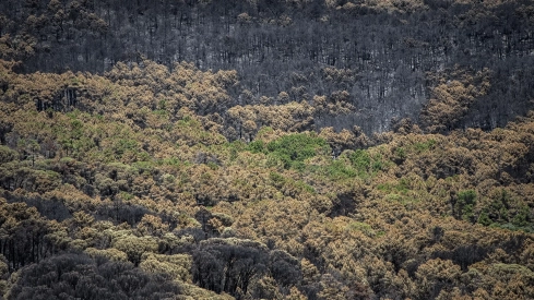
The Burgohondo forest fire remains far from its end almost two weeks after it started. The largest fire recorded in Spain will take at least another month to be declared extinguished and its surveillance will continue beyond the summer, according to the forecasts of the Castilla y León operation.
The fire maintains Potential Severity Index 2 and still does not meet the necessary conditions to be declared stabilized or controlled. Within its 160 kilometers of perimeter, there are embers and hot spots capable of reactivating with the wind and again threatening people, homes, and farms located outside.
"You have to be very sure," warned Miguel García, a technician from the Forest Fire Service of the Junta de Castilla y León. His comparison summarizes the real state of the fire. A burned area of these dimensions functions like a large charcoal pit, apparently extinguished in some points but with incandescent material under the ash.
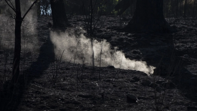
The danger was demonstrated last Sunday in La Adrada, in Alto Tiétar. A reproduction forced the evacuation again of the La Picota urbanization and several nearby buildings, just a few days after the return of its residents. Each episode of this type forces the operation to review the consolidated terrain and delays the step towards definitive control.
The Junta also does not rule out that one of the outbreaks detected on Monday near the El Horcajo dam, above Piedralaves, was a new fire. Its location outside the perimeter has led to an investigation into a possible intentional or imprudent origin. The Security Forces and Corps keep all lines open to determine what happened.
One month to completely extinguish 50,000 hectares
The difference between stabilizing, controlling, and extinguishing is decisive in a fire of this size. The fire can be considered stabilized when it evolves within the control lines without the capacity to open new fronts. The declaration of control requires that any internal flame be punctual and lack the possibility of exceeding the perimeter.
Extinction will arrive even later. The entire edge must be cold and the interior completely extinguished, including roots, hollow trunks, and accumulations of plant matter capable of retaining heat for weeks. García doubts that the fire can be declared controlled before fifteen days and estimates that its extinction will require at least one more month.
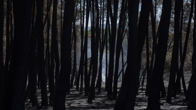
Rain also does not guarantee an immediate solution. The first intense storms could generate runoff on slopes devoid of vegetation and drag ashes, stones, earth, and calcined remains towards roads, riverbeds, and towns. The Junta technician has defined this scenario as one of the most dangerous for the coming weeks.
The fire started on July 22 in Burgohondo and advanced during its first hours at a speed of up to three kilometers in just 40 minutes. The Civil Guard investigation points to the use of an excavator working in a forest area when the use of machinery was prohibited due to extreme risk. The owner and the operator were investigated for their possible responsibility in the origin of the fire.
The flames crossed the Alberche Valley, Tierra de Pinares, the Sierra de Gredos, and the Tiétar Valley. Dozens of municipalities had to be evacuated or confined during the worst days, and the fire even converged with the large fronts open in Madrid and Toledo. The operation came to treat the entire area as a single complex of fires of more than 77,000 hectares and 280 kilometers of perimeter.
Homes, farms, and a natural reserve devastated
The more than 50,000 hectares burned in Ávila make Burgohondo the most extensive fire documented in Spain. The fire covered a large part of the municipalities of Piedralaves, Casavieja, and El Tiemblo, in addition to the surroundings of Navaluenga, Cebreros, La Adrada, and other towns in the province.
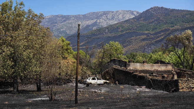
The Cadastre places around 1,200 buildings within the areas affected by the fires in Ávila, Madrid, and Toledo, more than 500 of them homes. This location does not imply that all have been destroyed, although the balance includes houses, warehouses, vehicles, agricultural exploitations, power lines, and forest roads damaged by the flames.
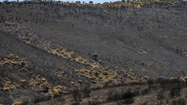
One of the most serious blows has occurred in the Iruelas Valley Natural Reserve. The fire has covered nearly 7,000 of its 8,000 hectares and has affected the habitat of one of Europe's largest colonies of black vultures, made up of about 120 pairs. Pine forests, holm oak groves, and refuge areas for roe deer and other species have been turned into a landscape of trunks and ash.
The centuries-old chestnut grove of El Tiemblo managed to be saved thanks to the work of residents and extinction teams. Among the protected specimens is "El Abuelo" (The Grandfather), a chestnut tree over five centuries old. The survival of the chestnut grove contrasts with the devastation suffered by the nearby slopes and a large part of the Iruelas Valley.
Reconstruction has already begun while the fire remains active. The Junta de Castilla y León has approved a program of 42 measures with a budget that can reach 90 million euros for the territories affected this summer, mainly in Ávila. The plan includes direct aid of 500 euros for displaced families and 5,500 euros for self-employed individuals, farmers, and businesses.
"Now comes the worst part, the reconstruction," acknowledged the mayor of Navaluenga, Armando García Cuenca. Municipalities will have to recover supplies, roads, paths, farms, and economic activity while the stability of the terrain is evaluated. The environmental recovery of the forest and protected areas will require years of monitoring.
Spain accounts for almost half of what has been burned in the EU
Burgohondo leads an exceptionally destructive fire campaign. Spain accumulated 219,665 hectares burned until July 29, 47.2% of all the surface area ravaged by fire in the European Union, according to the Copernicus EFFIS system.
The record is 5.1 times the surface area burned during the same period in 2025, when 42,700 hectares had burned. Spain also leads in the number of fires counted by the European system, with 382, ahead of Italy and France. The country had already reached nearly two-thirds of all that was burned during 2025 before August.
Last year ended with 354,793.5 hectares ravaged and became the worst since 1994. A large part of that balance was concentrated precisely during the first half of August. The current campaign has reached the month of highest risk with a burned area five times greater than that recorded a year earlier.
Madrid declares the wildfires in the Sierra Oeste controlled
The situation has improved more clearly on the other side of the autonomous border. The Community of Madrid has declared the fires that have affected 17 municipalities in the Sierra Oeste controlled and in the extinction phase and has lowered the Infoma Plan to Operational Situation 0.
Residents of seven urbanizations in Pelayos de la Presa and San Martín de Valdeiglesias have received authorization to return to their homes. These are El Mirador de Pelayos, Las Musas, Costa de Madrid, San Ramón, Javacruz, La Javariega, and Veracruz. Emergency services have asked to carefully check trees, buildings, and wiring and report any incidents to 112.
The prohibition of swimming and water activities remains temporarily in force in the San Juan reservoir and the Alberche beach. Firefighters, forest agents, and brigades continue with finishing and surveillance work to locate hot spots and prevent new outbreaks.
The first estimate places the affected area by the largest fire suffered in Madrid in recent decades at more than 27,000 hectares. The regional government has counted around a hundred primary homes destroyed and more than 300 houses with damages, in addition to impacts on roads, farms, vehicles, and basic services.
The Madrid executive is preparing the recovery of nearly 200 kilometers of roads and has enabled a temporary car-sharing service with 100,000 euros to facilitate essential travel. The measures reach 17 municipalities where more than 56,000 people live and also include support for families, businesses, self-employed workers, and livestock farms.
"We are going to rebuild this wonderful corner of the Community of Madrid," Isabel Díaz Ayuso assured, thanking the work of the emergency teams. The regional president has asked owners and tourists to maintain their connection with the Sierra Oeste while cleaning, damage assessment, and works progress.
The fires that remain active in Spain
The main active focus outside Ávila remains in Fermoselle, in Zamora. The fire has burned around 11,000 hectares in the Arribes del Duero Natural Park and forced the evacuation of 14 towns and the confinement of Fermoselle and Fariza.
Its evolution is favorable, although the teams continue to work on hot spots located in the most inaccessible areas of the Duero canyon. The complexity of the terrain prevents access by ground means to some sectors and forces aerial surveillance to be maintained until the perimeter is secured.
In Castellón, the fire started in La Vall d'Uixó remains stabilized but has not yet been declared controlled. The fire has devastated 9,568 hectares, maintains a perimeter of 89 kilometers, and has affected close to 12% of the Sierra de Espadán Natural Park. Outbreaks and the heat accumulated under the ash keep the extinction teams deployed.
Other recent fires, such as La Mierla in Guadalajara, have already entered the control and surveillance phase. Burgohondo continues to be the only fire that remains at Potential Severity Index 2 in Castilla y León, with brigades patrolling its 160 kilometers of perimeter to extinguish the embers that still survive within the largest burned area in the history of Spain.
Add ElConstitucional.es as a preferred Google source for free.
Stay informed about all the latest breaking news with the best information. Against disinformation, for democracy and social rights.
